Photos | Navigating the City
A hand points to a map in a book, plotting out the transportation routes and landmarks of a bustling metropolis.
BLIP-2 Description:
a book with a map of a city and a hand pointing to itChronologically Adjacent
Note: You can also navigate with your arrow keys or swiping.
Metadata
Capture date:
Original Dimensions:
3024w x 4032h - (download 4k)
Usage
Dominant Color:
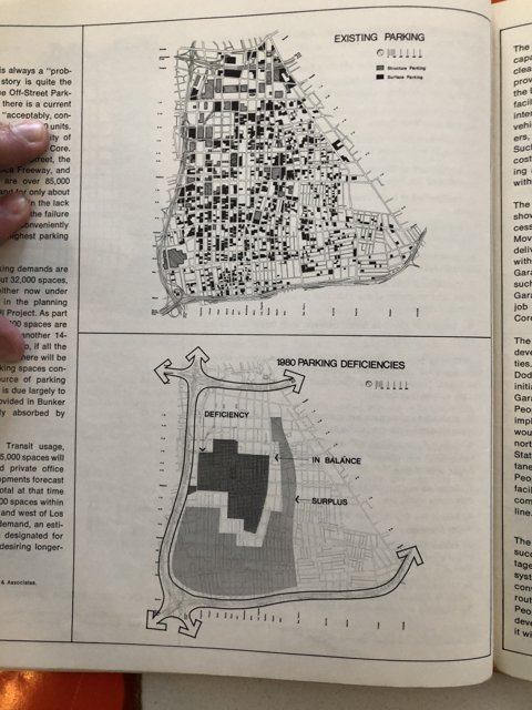
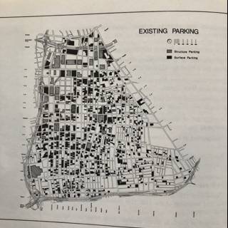
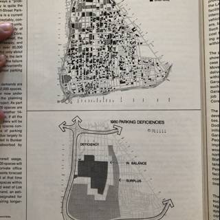
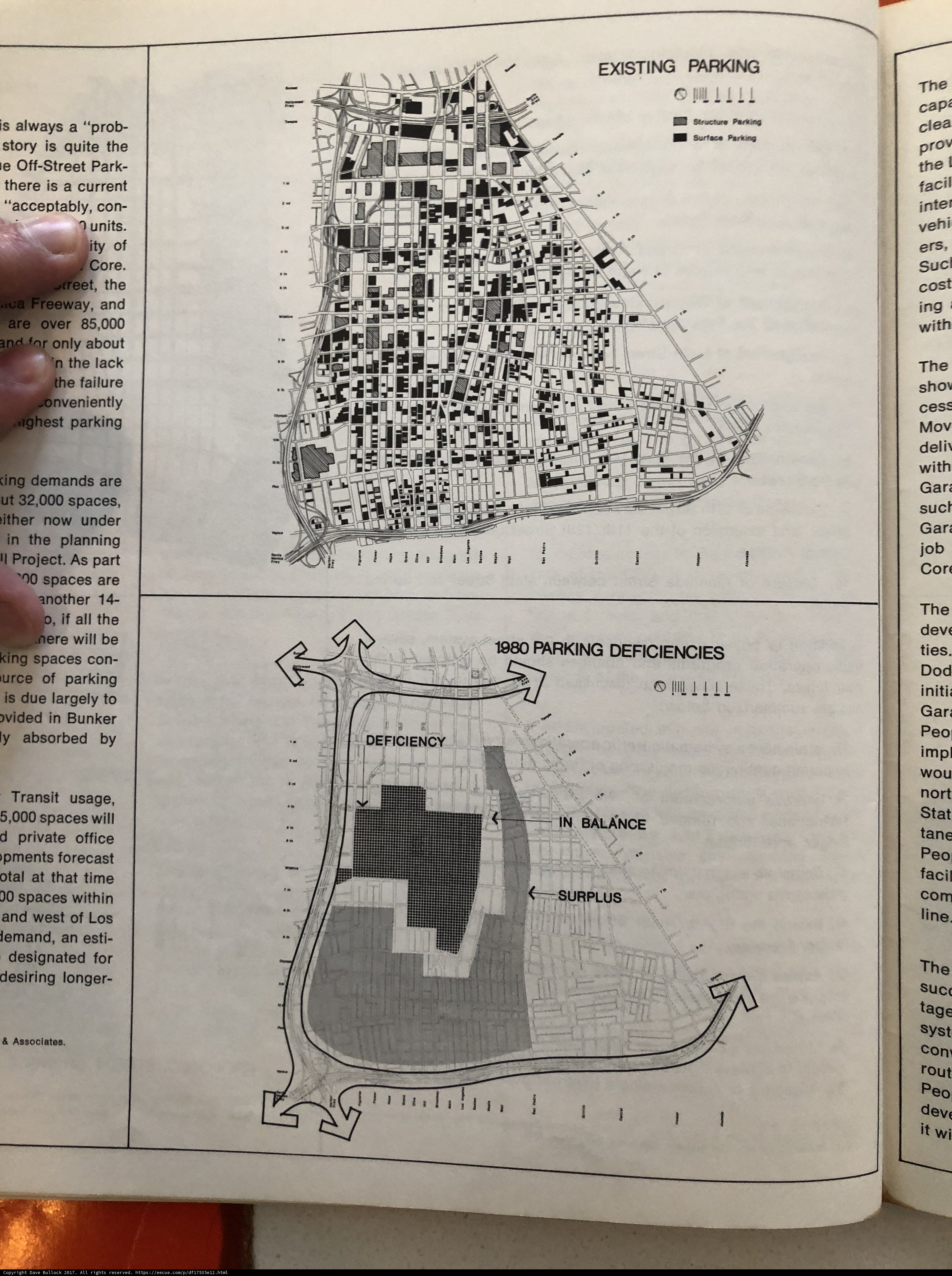
longer otal another due clea ties west forecast deficiency project va sucl freeway boat text suc imp ers chart story off associates diagram urce largely los onveniently vehi stat acceptably ing nort tane syst dod tage sho page spaces cap core transportation nere demands cad pments street ity bunker ighest king units line now map time book job absorbed rout vehicle ither ut designated mov devi treet prot lemand le surface cort cost private faci structure art document ly ovided cess parking prob wou office cor con part balance gar planning park existing wi 咢 usage quite publication plot lack desiring transit current initi failure plan facil drawing esti intel printed peo deli surplus deficiencies
Detected Text
00 10 14 1980 32,000 5,000 85,000 a about absorbed acceptably all always an and another are as associates at balance be bunker by cap cess clea con cor core cort cost current d deficiencies deficiency deli demands designated desiring devi dod due ers esti existing faci facil failure for forecast freeway gar i if ighest imp in ing initi intel is it ither ity job king l lack largely le lemand line longer los ly mov nere nort now o of off office only onveniently otal over ovided park parking part peo planning pments private prob project prot quite rout sho spaces stat story street structure suc sucl surface surplus syst tage tane that the there ties time to transit treet under units urce usage ut va vehi west wi will with within wou 咢
iso
40
metering mode
5
aperture
f/1.8
focal length
4mm
shutter speed
1/15s
camera make
Apple
camera model
lens model
date
2017-12-02T12:46:44.245000-08:00
tzoffset
-28800
tzname
America/Los_Angeles
overall
(1.94%)
curation
(25.00%)
highlight visibility
(2.44%)
behavioral
(70.23%)
failure
(-0.44%)
harmonious color
(-2.14%)
immersiveness
(0.17%)
interaction
(1.00%)
interesting subject
(-84.38%)
intrusive object presence
(-15.65%)
lively color
(6.32%)
low light
(0.12%)
noise
(-4.15%)
pleasant camera tilt
(-6.74%)
pleasant composition
(-34.47%)
pleasant lighting
(-0.24%)
pleasant pattern
(2.54%)
pleasant perspective
(6.13%)
pleasant post processing
(3.94%)
pleasant reflection
(-6.69%)
pleasant symmetry
(0.66%)
sharply focused subject
(1.10%)
tastefully blurred
(3.08%)
well chosen subject
(11.19%)
well framed subject
(3.26%)
well timed shot
(-1.49%)
all
(-1.40%)
* WARNING: The title and caption of this image were generated by an AI LLM (gpt-3.5-turbo-0301
from
OpenAI)
based on a
BLIP-2 image-to-text labeling, tags,
location,
people
and album metadata from the image and are
potentially inaccurate, often hilariously so. If you'd like me to adjust anything,
just reach out.